
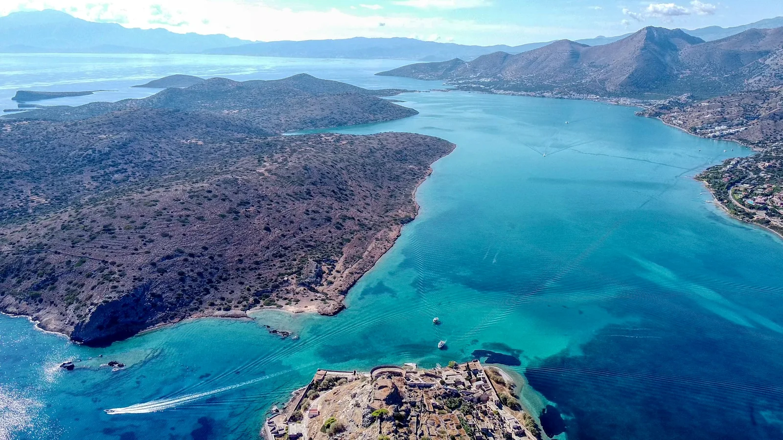
Mirabello is easiest to misunderstand when it is treated as one beautiful stretch of water with a succession of historical events placed around it. It is better read as a connected, uneven landscape: open sea and protected inlets, mountain valleys and small agricultural pockets, islands, peninsulas, shallows and narrow passages. The physical setting has remained recognisable, but different communities have repeatedly found different uses in it.
That is why Elounda belongs in a wider Mirabello story without becoming identical with the whole bay. The coast around Schisma, Poros, Kolokytha and Spinalonga is part of a smaller, shallow and comparatively protected system.
Agios Nikolaos faces more directly into the larger marine basin. Hillside settlements such as Mavrikiano belong to the same local geography but occupy a different topographic position from the waterfront; administratively, Mavrikiano is listed in the Municipal Community of Elounda. The result is one bay made into many different working, political and social spaces.
Before Mirabello Was “Mirabello”
A name at more than one scale
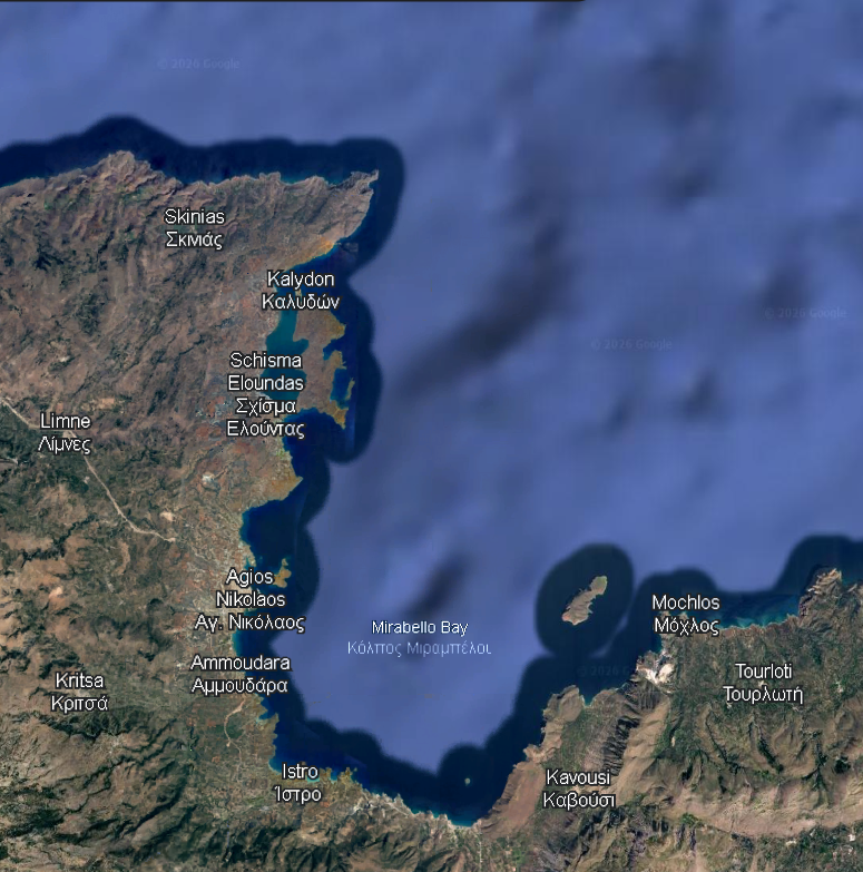
The name Mirabello is itself historical. It should not be projected unchanged into antiquity. Archaeologists and environmental researchers use it at more than one scale: sometimes for the broad northeastern-Cretan region, sometimes for the semicircular core bay around Agios Nikolaos, Istron and Pachia Ammos. The reviewed sources do not supply one official hydrographic delineation that resolves every use. In this article, Mirabello means the larger coast–sea–hinterland system within which the Gulf of Elounda is a distinctive, smaller part.
Elounda Bay is not simply another name for Mirabello Bay. Marine research describes it as shallow and semi-enclosed, relatively isolated from the outer coastal area of Mirabello. Kolokytha forms much of its eastern enclosure, while Spinalonga stands at the entrance to Elounda’s natural harbour. The word lagoon is useful only for the particularly shallow Poros and salt-pan threshold; it is not a formal synonym for the whole Gulf of Elounda.
This scale matters on the ground. Schisma is the coastal seat of the Municipal Community of Elounda. Epano Elounda and Mavrikiano are also listed within that community, rising above the waterfront and its lower roads. Plaka belongs to the separate Local Community of Vrouchas, even though its shore, road and view place it in the same northern coastal sequence. Everyday language often gathers these places under “Elounda”; the official and geographical distinctions are still worth keeping.
From fortified place to regional name
The medieval name should be handled with equal care. The earliest occurrence currently identified in the research is a 1212 record indexed as Mirabellum, a castellum; a 1234 record indexes Mirabello as a turma, an administrative district. Castrum Mirabelli then appears in the 1303 earthquake record, which notes the castle and its tower.
These records show that the name was in use at both fortified and administrative scales by the thirteenth century. They do not establish its invention or the absolute first historical use. The familiar story that Venetians simply admired a beautiful view and named the bay has no comparable documentary foundation.
Earlier coastal texts organise this shore differently. The ancient sailing itinerary known as the Stadiasmus Maris Magni moves between named ports, anchorages, capes and distances: Olous, Kamara and Istros, rather than a timeless Gulf of Mirabello. The 1234 record already demonstrates administrative use alongside the fortified place. Modern scholarly and geographical usage applies Mirabello to the wider gulf and region. The coast was not always divided, valued or named in the same way.
How the bay took shape
The physical geography helps explain why the names have never sat at one neat scale. At the broadest archaeological scale, the core bay is described as a semicircular basin of roughly 17 kilometres east to west and 10 kilometres north to south. Its southern and eastern shores receive short drainage corridors from the mountains at Agios Nikolaos, Ammoudara, Istron, Pachia Ammos and the Tholos–Kavousi side. These are not wide river plains. They are smaller openings where fresh water, cultivable ground and routes down from the hills meet the sea.
This form is the result of tectonics and longer surface processes, not a bay made by one fault. The Eastern Mirabello Fault System is part of the regional setting; erosion and short drainage routes have also carried sediment towards the coast. At Istron, a Holocene alluvial fan records how deposition and shoreline change have continued to alter the land–water edge.
Relative sea level adds another variable, especially around Olous, where archaeological evidence also points to local tectonic depression. Together, these processes explain a changing coastal setting without reducing Mirabello to a single geological event.
The outer basin is correspondingly open to the Sea of Crete. Agios Nikolaos sits on that more exposed Mirabello shore. North-west of it, the Gulf of Elounda forms a subsidiary maritime room, increasingly enclosed by the mainland, Kolokytha and the Spinalonga entrance.
At Poros, narrow ground and shallow water create an interface rather than a clean boundary: passage between the peninsula and Crete, archaeological terrain, later salt works, road, bridge and canal occupy the same compressed space. The contrast between open outer water and protected inner water made different uses possible within a short distance.
This is why Mirabello is best understood as a nested maritime landscape. The outer bay gave coastal settlements access to wider sea routes. Valleys and mountain routes connected it to agricultural and pastoral hinterlands. The protected Elounda basin supported small-scale fishing, sheltered anchorage and eventually salt production. The entrance around Spinalonga concentrated movement and made control possible. None of these zones can explain the others on its own, but together they explain why the region was repeatedly settled, worked, defended and renamed.
The history of the name follows that changing mental map. Later records use Mirabello for territory and administration as well as a fortified place, and the later use of Mirabello for the gulf made a medieval political name sound increasingly like a natural, permanent feature. The coast itself did not change its outline every time the name widened; what changed was the scale at which people organised, governed and imagined it.
A Sea of Connections
The larger bay was never a single harbour ruled by one settlement. Its surrounding mountains descend through short valleys and alluvial pockets towards the coast. Those valleys offered cultivable ground, water and routes inland; ridges offered visibility and defensible positions; small bays, promontories and islands created landing places and maritime connections. The sea joined these different settings rather than separating them.
Regional survey work around Gournia, Kavousi, Pseira and Vrokastro makes that pattern clear. The evidence does not tell a simple story of coastal rise, inland retreat and return. Instead, islands, slopes, agricultural land and shorelines were used in changing combinations. The eastern Mirabello landscape matters here because it shows linked sites and hinterlands rather than isolated towns.
Pseira, Istron and Priniatikos Pyrgos show the same point at a smaller scale. At Istron, an embayment and alluvial ground brought sea access and cultivable land close together. These places were not interchangeable; their different settings made a regional network possible.
The relationship between Lato and its maritime outlet at Kamara, in the present-day Agios Nikolaos area, is especially revealing. Lato occupied a defensible inland position, with access to territory and a commanding view across Mirabello; Kamara gave that political world a coastal outlet. This was not a division between an inland city and an unrelated port. It was a relationship between security, agricultural territory, routes and sea traffic. The disputes between Lato and Olous show that such relationships could create friction as well as exchange.
Olous was another part of that network, placed where the land narrows between Crete and the Kolokytha side. Ancient sailors could move along a chain from Olous to Kamara and onwards to Istros. For them, Mirabello was not an empty expanse to cross. It was a sequence of coastal nodes, with settlements, water, shelter and headlands close enough to structure short sea journeys.
The village landscape still makes this interdependence visible. Mavrikiano and Epano Elounda sit above the waterfront rather than merging with it. From the higher ground, the coast belongs to the view; from Schisma, the villages show how close the hillside settlement pattern remains. Walking Around Elounda and the Mavrikiano practical guide describe the present-day relationship between lanes, slopes and shore. Their purpose is practical; here, they also help explain the older relationship between upland ground and water.
Chrysokamino, Vrokastro and the Kavousi landscape add a different contrast between exposed coast and high ground. Some communities used visible and defensible positions, but settlement cannot be reduced to a simple story of refuge from pirates. Access to pasture, cultivable land, routes and maritime outlets also shaped choices. High places could provide oversight while remaining dependent on lower ground and the coast.
For sailors, that connection could be measured in short stages. In §§351–352, the Stadiasmus Maris Magni records Olous as 15 stades from Kamara and Kamara as 25 stades from Istros. The precise modern equivalence of an ancient stade is not the important point here. The sequence shows a coast experienced through the next reachable harbour, water source or cape. Sailors moving along it, farmers working the valley bottoms, quarry workers on the Kolokytha side and inhabitants of inland centres were using different parts of the same connected landscape.
This also helps keep the human scale in view. A harbour needed people to produce food, move goods and maintain links to its hinterland; an inland centre needed access to the coast without necessarily relocating to it. Lato and Kamara make that arrangement visible, but they were not unique. Around Mirabello, political territory, agriculture, production and maritime movement could occupy different places and still operate as one system.
Olous and the Moving Shoreline
Ancient Olous is often reduced to a phrase: “the sunken city of Elounda.” That phrase obscures more than it explains. Olous was a polis and harbour landscape centred on the present Poros area, where a narrow land-and-water threshold linked the Kolokytha peninsula to Crete. Its historical evidence is especially strong for the Archaic, Hellenistic, Roman and Early Byzantine periods, although the wider landscape also contains prehistoric activity.
A city across land, water and sediment
The archaeological landscape is terrestrial, submerged and buried. Ministry of Culture research by the Ephorate of Underwater Antiquities and the Institute for Mediterranean Studies has documented and mapped remains around Elounda Bay, the Kolokytha peninsula and both sides of Poros.
These include structural complexes, parts of fortification, coastal quarrying, mooring or loading features, anchors and other traces of maritime activity. Electrical and magnetic survey has also identified material below the seabed, beyond the remains visible from the shore or in shallow water.
This is why the whole city should not be imagined as lying intact beneath the surface. Parts of the archaeological landscape are on land, some are underwater, and others are covered by sediment. Nor should the visible remains be treated as a single Minoan city. Prehistoric use of the area is important, but the historically documented polis and much of the surviving urban evidence belong to later periods.
A shoreline changed over time
The changing shoreline is central, but it is not a settled single-event story. Research connects the present condition of parts of Olous with changing relative sea level, coastal morphology and possibly local tectonic movement. The Ministry’s account describes a city that flourished into the Early Byzantine period, was later abandoned, and probably then began to submerge. It does not identify one precisely dated earthquake, tsunami or landslide that “sank” Olous.
Poros is therefore more than a causeway on the road towards Kolokytha. It is a place where people repeatedly worked with a changing boundary between land and water: a polis and harbour landscape, a zone of quarrying and movement, later salt works, a canal and a bridge. The present shoreline does not reveal one lost city in one moment. It holds a long and still partly unresolved archaeological record.
The position helps explain why Olous was useful before it became difficult to interpret. The polis occupied an interface with access to protected water, small coves, the two sides of the Kolokytha landform and coastal routes towards the larger bay.
Its connection to the inland world was equally important. The long-running territorial tensions between Olous and Lato show that coastal access, land and sanctuaries could not be separated cleanly. A harbour polis and an inland political centre needed related resources, and their proximity made boundaries consequential.
What survey can—and cannot—show
The official underwater project has altered what can responsibly be said about the site. Photogrammetry documents exposed structures, while electrical-resistivity tomography and magnetic survey can register anomalies below sediment. The 2021 field report records features as much as 1.5 metres beneath the present seabed.
At Poros, remains of the urban centre and fortification occur on both sides of the isthmus and in the adjacent bay; research around Kolokytha has also recorded submerged complexes and quarries. The methods do not produce a finished map of the city, but they show why an underwater view alone cannot define Olous.
Changing relative sea level matters because it changes the question archaeologists are asking. It is not only a matter of whether water covered former buildings.
As the land–sea boundary moved, routes, mooring places, shore facilities and the usable width of the Poros threshold changed with it. The present submerged condition of parts of Olous is therefore evidence of a long coastal history, not proof of a single dramatic ending. This calmer account is more demanding, but it restores the city to the changing geography in which its inhabitants lived.
A Short Chronological History of Elounda provides a shorter introduction to this local sequence. The more specific point here is that the waterline itself has been part of the area’s history.
The Shallow Water Becomes Working Space
The sheltered margins of Elounda became productive infrastructure. Salt production depended on shallow water, evaporation, basins of controlled depth, the circulation of water and the movement of labour and goods. The Ephorate of Antiquities of Lasithi records salt works with possible Byzantine origins that Venice exploited early in its rule, distinguishing the larger Mesa Elounda complex from the smaller Oxo Elounda complex around modern Schisma. Archival material describes settling and evaporation basins of decreasing depth: constructed surfaces through which water was directed, settled, concentrated and harvested.
The system also depended on people beyond the immediate coast. The Ephorate links much of the work to villages in the Fourni area and connects salt-pan labour with coastal habitation. After Venice lost Cyprus in 1571, Cretan salt gained added importance; Spinalonga was fortified from 1579. Salt, harbour access and defence should not be collapsed into one cause, but the protected water that sustained salt production also helped make this shore strategically valuable.
Ottoman restoration after Venetian destruction of the works in 1653, and operation under the Greek Salt Monopoly into the twentieth century, show that the landscape remained productive across changes of rule.
The windmills by Poros remain a useful marker of this working threshold. The Ephorate identifies three round windmills near the canal, built in local stone and now protected monuments. Together with the bridge, road, cut and salt-pan ground, they make a compact record of different practical uses of the same narrow site. The dedicated article, Elounda Salt Pans and the Poros Windmills, follows that local landscape in more detail.
What appears today as flat water and low ground was once a managed sequence of surfaces, channels, embankments and working routines. The Fourni connection gives it an inland human geography: labour, storage, transport and administration tied upland settlements to an exposed coastal edge. The landscape visible today still retains that outline, even though the work that animated it has gone.
The Entrance Becomes Military Space
Spinalonga matters because of where it is. The rocky islet stands at the mouth of Elounda’s natural harbour, between the sheltered water inside and the wider approaches from Mirabello Bay. Its position did not make it a universal guardian of the whole gulf. It gave it unusual importance in controlling and defending the entrance to the harbour and the economically valuable coast behind it.
Venice fortified the island within a late-sixteenth-century defensive programme, beginning in 1579. Its ridge, shore and relation to neighbouring high ground shaped the fortress’s response to terrain and artillery. After the fall of Candia in 1669, it remained a Venetian enclave until 1715. The essential point here is geographical: a narrow entrance could turn a small island into a military space because it concentrated movement towards the settlements and productive shore behind it.
Spinalonga: Why It Was Fortified and How the Island’s Uses Changed gives the full account of the fortress, Ottoman town, later uses and evidence limits.
Elounda contained protected interior water, a shoreline made valuable by salt production and settlement, and approaches from the larger Mirabello basin. A force entering or leaving the harbour passed a narrow zone dominated by an island whose height, shore and relation to the peninsula could be fortified. Its later history as an inhabited Ottoman town underlines that a choke point can be a settlement as well as a fortification; the detailed chronology belongs in the dedicated article.
The Same Geography, a Different Form of Control
The physical separation that had military value later acquired a radically different social use. In 1903, the Cretan State chose Spinalonga for the compulsory isolation of people with Hansen’s disease; the first transfers followed in 1904. The island’s water boundary, existing buildings and distance from the mainland made that policy practicable.
This was not a continuation of fortress life under another name. It was a different system, imposed through public-health policy and social stigma. Residents formed households and collective organisations within it, but that agency does not remove the coercive character of compulsory separation. The institution closed in 1957.
The contrast is important for Mirabello as a whole. The same island had been made into a fortified entrance, an Ottoman settlement, a place of isolation and later an archaeological monument. Its landform did not dictate one meaning. Institutions repeatedly assigned it new ones. The dedicated Spinalonga article gives this history the space and care it requires.
The change can be described precisely without making people disappear from it. In the fortress period, control concerned movement through the harbour entrance and the protection of a strategic shoreline. In the twentieth-century institution, the object of control was movement to and from the island itself. Residents of Spinalonga made homes, worked, organised and pressed for better conditions within a regime they had not chosen. The same water that once helped define a military boundary now enforced compulsory separation.
That difference is central to the wider argument. Geography supplied a controllable separation, but it did not determine the institution. Political authority, medical assumptions and social stigma made that separation into a system of isolation. The later archaeological monument preserves the physical setting while asking visitors to read several incompatible purposes in the same streets and walls.
When People Began to Redesign the Coast
People had long altered this coast through salt works, quarrying and fortification. In the twentieth century, harbour works, roads, sea walls, groynes and constructed beaches did so at a different scale, intensity, with different materials and for more concentrated public and commercial purposes.
A coastal-geomorphology study of Elounda Bay records the construction of the local harbour around 1970, its expansion in the 1980s, a groyne north of the port that helped form the municipal beach, and seawall protection along other sections. These are not incidental additions to an otherwise unchanged coast. They are part of the physical history of the bay, affecting sediment movement, access and the form of the waterfront.
Tourism development was one reason for this concentration of intervention, but it should not be treated as the only modern use of the coast. Marine research documents a productive shallow-water ecosystem in Elounda Bay, but it does not establish the present scale of fishing activity. Archaeological remains, salt-pan structures, roads and beaches occupy the same small geography.
Schisma’s present waterfront is part of that later concentration of activity. Mavrikiano and Epano Elounda remain above it; Plaka remains north in the separate Local Community of Vrouchas. The old distinctions have not disappeared, even though modern road access and development make the area feel more continuous than it once did.
The coastal study makes the mechanism visible. A harbour and its expansion alter currents, wave exposure and sediment movement near shore; a groyne can retain material and help form a beach, while seawalls protect particular edges but change the relation between land and water.
These interventions are practical responses to modern requirements, but they also become part of the bay’s form. Modern Elounda did not replace an empty past: it added infrastructure and new forms of value to a coast already dense with work, settlement and memory.
Mirabello Today: The Layers Remain
Looking across Mirabello now, it is easy to see one coast. The historical landscape is more layered. The open marine basin and smaller protected waters supported navigation in different ways. Valleys and agricultural pockets linked the shore to the hinterland. Olous used the Poros threshold as a maritime polis and harbour landscape. Salt workers used shallow margins as controlled productive ground. Spinalonga made the harbour entrance a military space, then a place of compulsory isolation. Modern engineering has reshaped parts of the waterfront for harbour and beach use.
From the hills above Elounda, the relationships are still physically legible. The mountain slopes fall towards small agricultural pockets and older inland settlements. Schisma gathers modern waterfront activity on the lower coast. Beyond it lie the Poros threshold and Kolokytha, where archaeological remains, salt-pan ground, canal and windmills share a narrow strip of land and water. Spinalonga marks the harbour entrance, while the outer water opens towards Agios Nikolaos and the larger Mirabello basin.
Not everything can be seen directly. Parts of Olous lie in shallow water or beneath sediment, and some of the work that made the salt pans function survives only in plans, records and the shape of the ground.
The routes of ancient sailors, the labour of quarry workers and the routines of people who harvested salt have to be recovered through archaeology and documents. Mirabello is recognisable across time, but it has never meant the same thing to every group who used it: a chain of coastal stages, inland and maritime territories, a working salt landscape, a fortified entrance, a place of enforced separation and an engineered waterfront.
Sources and Image Credits
- Local Urban Plan Study for the Municipality of Agios Nikolaos, Ministry of Environment and Energy / Municipality of Agios Nikolaos.
- Maidanou, M., Koulouri, P., Arvanitidis, C., Koutsoubas, D., and Dounas, C. (2017), “Macrobenthic assemblage structure associated with a Caulerpa prolifera meadow in the eastern Mediterranean Sea (Elounda Bay, Crete Island)”, Regional Studies in Marine Science.
- Surveys in the Mirabello region, INSTAP Study Center for East Crete.
- Baldwin Bowsky, M., “Portrait of a Polis: Lato Pros Kamara (Crete) in the Late Second Century B.C.”, Hesperia 58(3).
- Underwater research in ancient Olous and at the port of Ierapetra, Hellenic Ministry of Culture.
- Simyrdanis, K., Papadopoulos, N., and Cantoro, G. (2016), “Shallow Off-Shore Archaeological Prospection with 3-D Electrical Resistivity Tomography: The Case of Olous (Modern Elounda), Greece”, Remote Sensing 8(11), 897.
- Salt Pans and Windmills in Poros, Ephorate of Antiquities of Lasithi.
- The construction phases of Spinalonga, Ottoman times, and Modern times, Ephorate of Antiquities of Lasithi.
- Petrakis, S., Alexandrakis, G., Rempis, N., and Kampanis, N. (2019), “Coastal geomorphological changes in a semi-enclosed bay, induced by recreational interventions”, 1st International Conference on the Design and Management of Port, Coastal and Offshore Works.
- Places of the Greek-Venetian World: Mirabello, National Hellenic Research Foundation database (records Mirabello as a castellum in 1212 and a turma in 1234).
- Guidoboni, E., and Comastri, A. (1997), “The large earthquake of 8 August 1303 in Crete”, Journal of Seismology 1, 55–72.
- Stadiasmus Maris Magni, in C. Müller (ed.), Geographi Graeci Minores, vol. 1 (1855), pp. 427–514, §§351–352.
- Ancient Olous, Elounda — 2021, Ephorate of Underwater Antiquities and FORTH / Archaeology in Greece Online.
- Plageras, A. D., et al. (2021), “Geophysical Survey of Underwater Archaeological Sites in Greece”, Remote Sensing 13, 1237.
- Mouslopoulou, V., et al. (2019), “Millennial to million year normal-fault interactions in the forearc of a subduction margin, Crete, Greece”, Journal of Structural Geology.
- Theodorakopoulou, K., et al. (2012), “Sedimentological response to Holocene climate events in the Istron area, Gulf of Mirabello, NE Crete”, Quaternary International.
- Hero image: Photograph by Evangelos Mpikakis / Unsplash.